
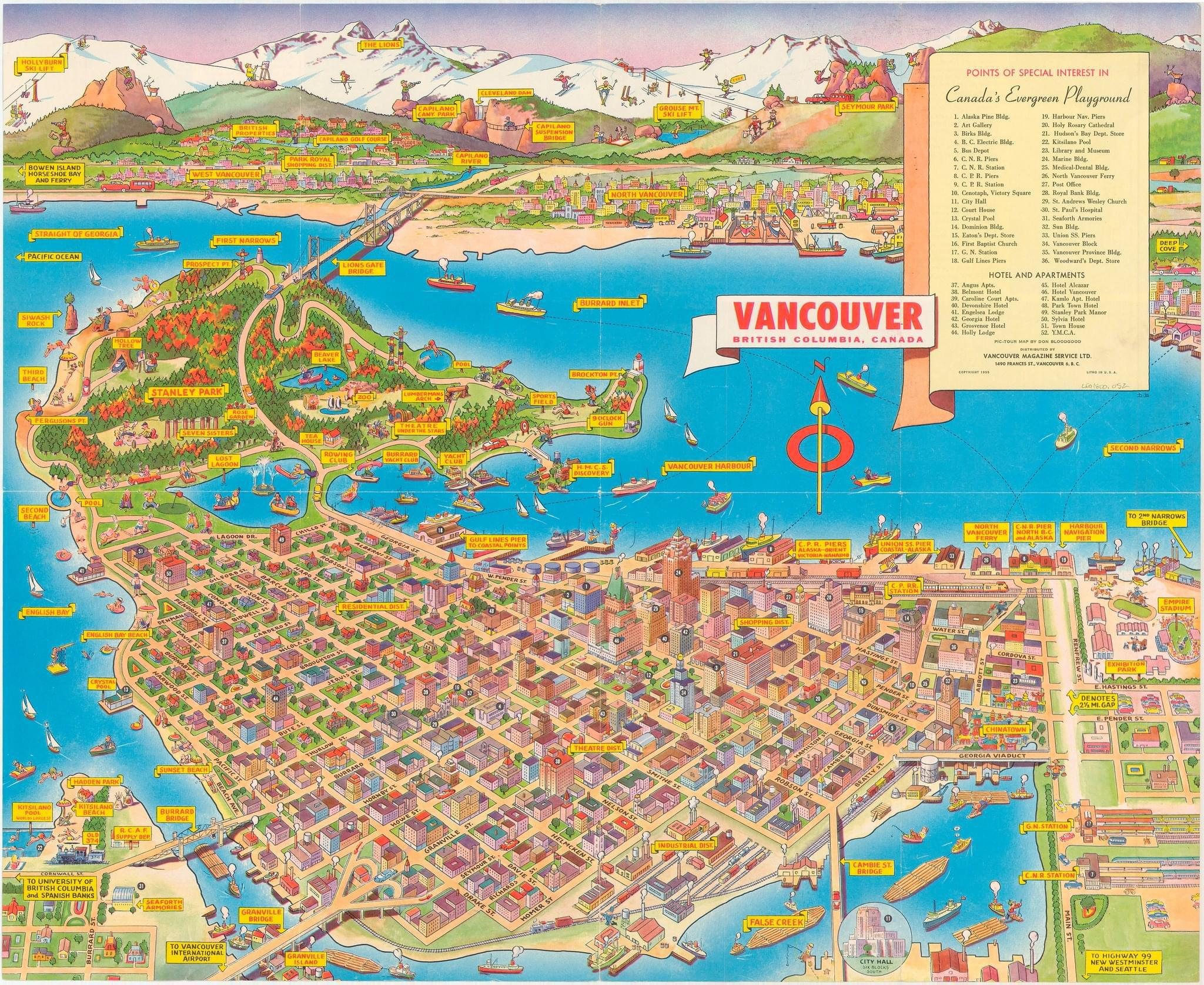
In 1955, Vancouver was a bustling, picturesque city nestled between the Pacific Ocean and the majestic mountains of British Columbia. A vintage map from that year offers a nostalgic glimpse into a city that was already a vibrant hub of culture, commerce, and natural beauty. Let’s embark on a journey through this beautifully illustrated map, uncovering the charm and allure of 1950s Vancouver.
Stanley Park: The Crown Jewel
One of the most striking features of the 1955 map is Stanley Park, a sprawling green oasis that remains one of Vancouver’s most beloved landmarks. The park is depicted with lush greenery and a variety of attractions. Visitors in 1955 would have enjoyed the serene beauty of Lost Lagoon, the cultural richness of the Totem Poles, and the breathtaking views from Prospect Point. The map also highlights the Vancouver Aquarium, which continues to be a popular destination for families and marine life enthusiasts.
A Maritime Hub: Vancouver’s Harbour
Vancouver's harbour is prominently featured, showcasing the city's strong maritime heritage. The map illustrates an array of ships and boats, emphasizing Vancouver’s status as a key port city. The bustling waterfront would have been alive with the comings and goings of cargo ships, fishing vessels, and recreational boats, painting a picture of a city deeply connected to the sea.
Downtown Vibrancy
The detailed depiction of downtown Vancouver on the map reveals a grid of streets filled with significant buildings and landmarks. Notable structures like the Vancouver Hotel, City Hall, and the Public Library are highlighted, indicating the civic pride and architectural diversity of the era. This area would have been a hive of activity, with streetcars and pedestrians moving through the heart of the city.
Bridges to the North Shore
The map also features the iconic bridges connecting Vancouver to the North Shore. The Lions Gate Bridge, with its graceful suspension design, stands out as a symbol of engineering prowess. The Second Narrows Bridge (now the Ironworkers Memorial Bridge) is also depicted, underscoring the city’s expanding infrastructure and its role in facilitating regional connectivity.
Nature and Recreation
Beyond Stanley Park, the map highlights several other areas of natural beauty and recreational importance. Grouse Mountain, with its snowy peaks, would have been a popular destination for skiing and outdoor adventures. The surrounding areas, including Bowen Island and Deep Cove, offer glimpses of the outdoor lifestyle that Vancouverites have always cherished.
Points of Interest
The map’s sidebar lists numerous points of interest, providing a snapshot of the cultural and social life in 1955. Landmarks such as the Vancouver Art Gallery, Christ Church Cathedral, and the Marine Building are noted, each contributing to the rich tapestry of the city’s heritage. Hotels and apartments are also listed, indicating the accommodations available to visitors and new residents drawn to the city’s opportunities.
Conclusion
This 1955 map of Vancouver is more than just a navigational tool; it is a window into the past, reflecting a city on the cusp of modernity yet deeply rooted in its natural surroundings and maritime traditions. As we explore this vintage map, we are reminded of the enduring qualities that continue to define Vancouver: its stunning landscapes, vibrant downtown, and welcoming spirit. Whether you are a history buff, a geography enthusiast, or simply someone who loves Vancouver, this map offers a delightful journey through time, celebrating the essence of Canada’s evergreen playground.
![]()
#MetroVancouverRealEstate #HousingMarketUpdate #RealEstateTrends 🏡📊