
Transit Systems In Vancouver BC
There are several options for getting around Vancouver, BC. The city has an extensive public transit system, including buses, trains, and ferries. The main transit provider in the city is TransLink, which operates buses, trains, and the SeaBus ferry.
Buses:
One option for getting around the city is to use the bus system. TransLink operates buses that serve many areas of the city, including downtown Vancouver. The buses run on a regular schedule and can take you to many popular destinations.
Skytrain:
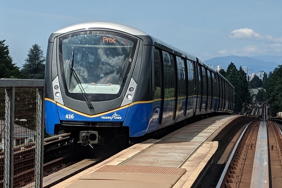
Another option for getting around Vancouver is to use the SkyTrain, which is the city's rapid transit system. The SkyTrain is the rapid transit system in Vancouver, BC. It is operated by TransLink, the city's main transit provider. The SkyTrain has three lines: the Expo Line, the Millennium Line, and the Canada Line. The Evergreen Line is an extension of the Millenium Line.
The Expo Line runs east-west through the city, connecting downtown Vancouver with the suburbs of Burnaby, New Westminster, and Surrey. The Millennium Line runs north-south through the city, connecting downtown Vancouver with the suburbs of Coquitlam and Port Moody. The Canada Line is an underground line that connects downtown Vancouver with the airport and the suburb of Richmond.
The SkyTrain is a convenient and reliable way to get around Vancouver. It runs on a regular schedule, and many of the stations are wheelchair accessible. The trains are also clean and safe, making it a popular transportation option for residents and visitors alike.
SeaBus Ferry:
In addition to the buses and SkyTrain, you can also use the SeaBus ferry to get around Vancouver. The SeaBus is a passenger ferry that operates between downtown Vancouver and the North Shore. It is a quick and convenient way to cross the Burrard Inlet.
Overall, there are many options for getting around Vancouver, BC. Whether you prefer to use buses, trains, or ferries, you should have no trouble finding a convenient and reliable way to get to your destination.
Cost:
The cost of using the TransLink lines in Vancouver, BC, varies depending on the type of fare that you purchase and the distance that you travel. There are several types of fares available, including single-use fares, day passes, and monthly passes.
Single-use fares are the most basic type of fare, and they allow you to ride one bus, train, or ferry. These fares are valid for two hours from the time of purchase, and they allow you to transfer between different modes of transportation within that time. Single-use fares start at $2.95 for adults, $1.90 for children and youth (ages 5-18), and $1.90 for seniors (ages 65+).
Day passes are a convenient option if you plan to use public transit for multiple trips in a single day. Day passes allow you to ride as many buses, trains, and ferries as you like within a 24-hour period. Day passes cost $10.50 for adults, $7.00 for children and youth, and $7.00 for seniors.
Monthly passes are the most cost-effective option if you plan to use public transit regularly. These passes allow you to ride as many buses, trains, and ferries as you like within a calendar month. Monthly passes cost $98 for adults, $64 for children and youth, and $64 for seniors.
In addition to the regular fares, TransLink also offers reduced fares for people with disabilities and low-income individuals. More information about these fares is available on the TransLink website.
Highways and Freeways:
Vancouver, BC, is served by a network of highways and roads that connect the city with other areas of the province and the country. The main highways that serve Vancouver include:
Highway 1: This highway, also known as the Trans-Canada Highway, is the main route through Vancouver. It runs east-west through the city, connecting downtown Vancouver with the suburbs of Burnaby, New Westminster, and Surrey.
Highway 99: This highway, also known as the Fraser Highway, runs north-south through the city, connecting downtown Vancouver with the suburbs of Delta and White Rock. It also continues south into the United States, where it becomes Interstate 5.
Highway 91: This highway, also known as the Richmond-Delta Highway, runs east-west through the city, connecting downtown Vancouver with the suburb of Richmond.
Highway 17: This highway, also known as the Oak Street-South Fraser Perimeter Road, runs north-south through the city, connecting downtown Vancouver with the suburbs of Delta and Surrey.
Highway 99A: This highway, also known as the Sea Island Connector, runs east-west through the city, connecting the suburb of Richmond with the Vancouver International Airport.
Highway 7: This highway, also known as the Lougheed Highway, runs east-west through the city, connecting downtown Vancouver with the suburbs of Burnaby and Coquitlam.
Highway 15: This highway, also known as the King George Boulevard, runs north-south through the city, connecting downtown Vancouver with the suburb of Surrey.
Highway 91A: This highway, also known as the Annacis Highway, runs east-west through the city, connecting the suburbs of Delta and New Westminster.
Highway 10: This highway, also known as the King George Highway, runs north-south through the city, connecting downtown Vancouver with the suburbs of Surrey and Langley.
Overall, Vancouver is well-served by a network of highways and roads that connect the city with other areas of the province and the country. These highways make it easy to travel to and from Vancouver, whether you are coming from nearby cities or from farther away.
Thinking of moving to Vancouver? Give us a call or sign up to get new listings.
![]()